
GNSS interference near Port Sudan: Patterns, escalation, and geopolitical implications

Ship bridge navigation systems with radar and digital displays. Source: AI-generated
21 May 2026
This brief assesses the emergence and evolution of GNSS interference activity in the vicinity of Port Sudan amid Sudan’s ongoing civil war. Analysis of interference events between April 2023 and April 2026 shows a clear temporal and spatial correlation with key phases of the conflict, particularly RSF aerial and drone strikes, suggesting reactive use of electronic warfare as a countermeasure rather than persistent area denial. The increasing intensity and offshore reach of the interference from mid‑2025 onward point to the deployment of more capable, military‑grade systems, potentially reflecting external support to the Sudanese Armed Forces. These developments underline Port Sudan’s growing strategic significance in broader regional and international competition and highlight rising navigational risks for commercial maritime actors operating in the Red Sea.
By Sofia Noor Steensma Tedder - Security Analyst Intern
Global Navigation Satellite System (GNSS) interference refers to unauthorised radio transmissions at frequencies used by legitimate navigation services, degrading position, navigation, and timing functions that military and maritime operations depend on. In conflict environments, GNSS interference is commonly used as a defensive electronic warfare measure, particularly to degrade the effectiveness of precision-guided weapons and unmanned aerial systems that rely on satellite navigation.
One area where GNSS interference activity has been increasingly reported is the vicinity of Port Sudan, a strategic logistics hub on the Red Sea currently under the control of the Sudanese Armed Forces (SAF). Since the outbreak of Sudan’s civil war in 2023 between the SAF and the Rapid Support Forces (RSF), the port has assumed heightened strategic importance. Sudan’s Red Sea access, mineral resources, and geographic positioning near important maritime routes have attracted competing regional and international interests, with both opposing sides reportedly receiving external military support.
Analysis of GNSS interference events recorded near Port Sudan between April 2023 and April 2026 indicates that activity has evolved in parallel with key phases of the conflict. Interference levels remained relatively low through mid‑2023 before a first notable increase coincided with RSF strikes on SAF coalition headquarters in Deim in November 2023. A second increase occurred in August 2024, followed by the most intense period of disruption observed, peaking around RSF drone strikes on Port Sudan in May 2025. This temporal clustering around kinetic events is consistent with GNSS interference being deployed reactively, likely as a countermeasure to aerial strike capabilities rather than as a continuous area‑denial system.
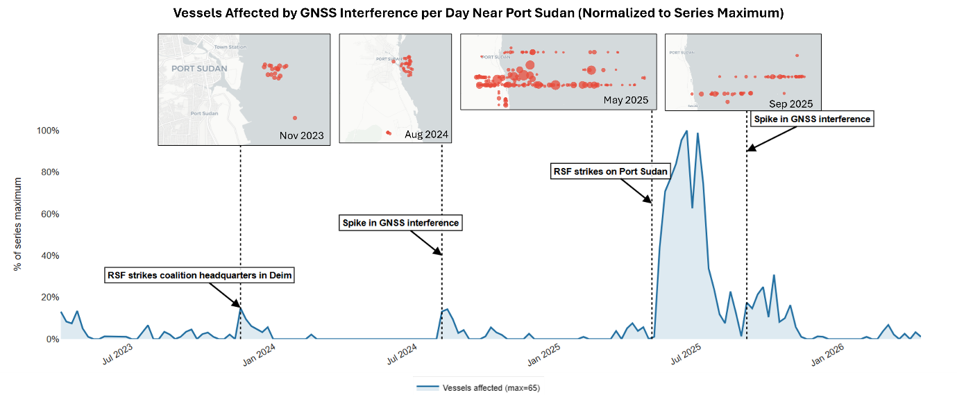
Data: AIS vessel data (01.04.2023-28.04.2026) coverage of a geographically bounded circle (point: 19.79, 37.78; r=50NM)
The spatial distribution of affected vessels over time suggests an evolution in the technical characteristics of the interference. Prior to mid‑2025, disruptions were largely confined to vessels operating close to the coastline. From May 2025 onward, however, interference effects were observed at distances of at least 150 km offshore. This expanded footprint is indicative of more powerful or better‑configured systems, consistent with modern, military‑grade electronic warfare capabilities rather than ad hoc or commercially improvised equipment.
These developments carry broader geopolitical implications. There is limited public evidence that the SAF possesses, indigenously and at scale, the technical expertise and infrastructure required to deploy high‑power, wide‑area GNSS interference systems. When combined with the close temporal alignment between interference spikes and RSF attacks near the port, as well as documented military cooperation between the SAF and external partners such as Iran and Russia, the available data support the assessment that at least some of the interference capability may be externally supplied, assisted, or operated.
Port Sudan should therefore be understood not only as a logistics node in a domestic civil war, but as a strategic hub whose control has implications for regional power projection in the Red Sea. GNSS interference in this area has spillover effects beyond the immediate military context. Commercial shipping operating offshore experiences degraded navigation reliability, increasing operational risk in an already unstable security environment.
The evolution of GNSS interference near Port Sudan is best interpreted not as an isolated or localised military phenomenon, but as an indicator of how Sudan’s conflict is becoming increasingly embedded in broader geopolitical competition. As electronic warfare capabilities proliferate and are deployed in support of contested strategic infrastructure, maritime operators are likely to face rising exposure to indirect but consequential conflict effects.
RELATED CONTENT:
Discover further insights into GNSS spoofing, which is an ongoing concern for the maritime industry:
Maritime navigation under threat: GNSS spoofing raises security concerns
MARITIME SECURITY REPORTS:
Our Risk Intelligence reports provide valuable insights to assess the risks of specific routes and support decision-making with detailed threat assessments.
The Voyage Risk Assessment focuses on a vessel’s specific route and offers an independent third-party perspective on the necessary security measures. The Monthly Intelligence Report delivers comprehensive analysis of recent incidents and a threat assessment for three key regions, available via subscription.